
We whipped up a storm at the Data.gov.uk launch, demoing our Local Transport Posters and storytelling with visualisation.
See the video here:
Data.gov.uk Launch from ItoWorld on Vimeo.
I would like to point out that I don't usually scratch my nose so much, but sharing a stage with Sir Tim Berners-Lee is rather nerve-wracking!
Interested in the posters or our visualisation expertise? Contact sales@itoworld.com
Monday, 25 January 2010
Thursday, 21 January 2010
Ito World at the Data.gov.uk Launch
Just off stage at the launch of data.gov.uk, here's the slides:
Ito World at Data.gov.uk Launch
The Local Transport Posters we make don't show up well in the above slides, here's the real deal.

Flickr gallery of visualisations here.
Ito World at Data.gov.uk Launch
The Local Transport Posters we make don't show up well in the above slides, here's the real deal.

Flickr gallery of visualisations here.
Data.gov.uk Launch
Exciting times! Data.gov.uk launches today and we are presenting at the launch event. Read more about it at the BBC and Guardian. We will be posting slides and other media from the event later today, and Tweeting from the @itoworld Twitter account.
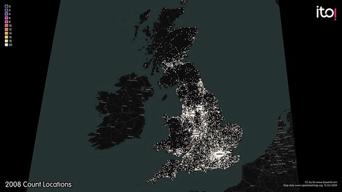
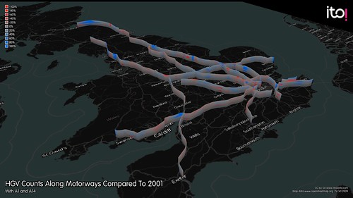
This is some of what we'll be showing off:
And our work has just been featured on the excellent Flowing Data blog.
This is some of what we'll be showing off:
And our work has just been featured on the excellent Flowing Data blog.
Wednesday, 20 January 2010
Mapping the Crisis - OpenStreetMap Response to Haiti Earthquake
Since the Haiti Earthquake, there has been an incredible response from the OpenStreetMap community to map Haiti for use by aid agencies on the ground.
Before the quake, Haiti looked like this.

And now looks like this.
View Larger Map
During the response, it was clear that better coordination tools were needed. With regards to OpenStreetMap editing, a tool to show where edits were occurring and where further efforts should be focused was necessary.
Our own OSM Mapper, currently runs on a 48hour update cycle and was of little use for coordinating live, crowdsourced map edits. We hope to be running on a much shorter update cycle in the future, which should be of more use for coordination during future events. However, it does give us some useful insight after the event.
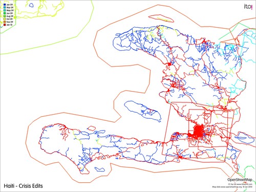
Looking at the OSM edits up to midnight 15th of January, red edits are the most recent. We can see a focus on Port-au-Prince and surrounding urban areas, which are presumably the worst affected. However, as relief efforts focused on the capital, access and awareness of the surrounding localities will be limited. These areas need to be mapped too and some mappers encouraged to make edits away from the main urban centres.
Looking through the tagging, 147 spontaneous camps of people displaced by the earthquake had been identified and tagged on the map. OSM Mapper has a handy KML export option, allowing you to focus on just one tag and export all the relevant features from OpenStreetMap in KML.
You can download the KML file of spontaneous camps here.
We are looking at running an update, and will get some images online to show progress after 15th January.
Before the quake, Haiti looked like this.
And now looks like this.
View Larger Map
During the response, it was clear that better coordination tools were needed. With regards to OpenStreetMap editing, a tool to show where edits were occurring and where further efforts should be focused was necessary.
Our own OSM Mapper, currently runs on a 48hour update cycle and was of little use for coordinating live, crowdsourced map edits. We hope to be running on a much shorter update cycle in the future, which should be of more use for coordination during future events. However, it does give us some useful insight after the event.
Looking at the OSM edits up to midnight 15th of January, red edits are the most recent. We can see a focus on Port-au-Prince and surrounding urban areas, which are presumably the worst affected. However, as relief efforts focused on the capital, access and awareness of the surrounding localities will be limited. These areas need to be mapped too and some mappers encouraged to make edits away from the main urban centres.
Looking through the tagging, 147 spontaneous camps of people displaced by the earthquake had been identified and tagged on the map. OSM Mapper has a handy KML export option, allowing you to focus on just one tag and export all the relevant features from OpenStreetMap in KML.
You can download the KML file of spontaneous camps here.
We are looking at running an update, and will get some images online to show progress after 15th January.
Tuesday, 12 January 2010
London Datastore Update
Here is the exact text from Deputy Mayor Sir Simon Milton's speech, at the London Datastore launch:“I can confirm today, however, that as a result of our discussions around the Datastore, TfL are willing to make raw data available through the Datastore. Initially this will be data which is already available for re-use via the TfL website, including live feeds from traffic cameras, geo-coded information on the location of Tube, DLR and Overground stations, the data behind the Findaride service to locate licensed mini-cab and private hire operators and data on planned works affecting weekend Tube services. “TfL will also be considering how best to make available detailed timetabling data for its services and welcomes examples of other data which could also be prioritised for inclusion in the Datastore such as the data on live departures and Tube incidents on TfL’s website.”
Friday, 8 January 2010
London's Datastore Launch

[photo credit Paul Clarke]
Yesterday, I was invited along to the launch of London's Datastore, the first step of freeing up London's datasets. Despite technical failures, Mayor Boris gave a masterful display of public speaking and quippery, telling us how excited he was by the prospect of increased transparency and citizen involvement in service delivery that is enabled by open data.
It has become clear that open data is now entering the political main stream, with data.gov.uk and now the London Datastore leading the way with UK goverment datasets. We were particularly thrilled that Transport for London has committed to releasing transport data through the Datastore. Among the transport data released are:
Abandoned vehicles
Accessibility indicators from TFL
British Transport Police: recorded crimes
Bus Driver Incident Reports
Number of licenced vehicles
Parking penalties
Road Accident Data
Road injuries and deaths
TFL data on transport use
Traffic flows
Train Overcrowding
[full list here]

TfL has committed to making detailed timetable data available for London's transport system. Well done TfL!
This will lead to a wealth of new internet and mobile applications that give passengers, personalised travel information for the busy city.
You can see many great examples of transport applications, all powered by open data, catalogued by our friends at City-Go-Round.
Our thanks go to Emer Coleman for all her hard work in creating the London Datastore.
Subscribe to:
Posts (Atom)

